send link to app

DishPointer Augmented Reality app for iPhone and iPad


4.2 ( 9732 ratings )
Productivity Education
Developer: DP Technologies Ltd
9.99 USD
Current version: 2.1.4, last update: 7 years ago
First release : 03 Aug 2009
App size: 273.18 Kb

Point your phone towards the sky and see on the live camera screen where the satellites are, any line of sight (LoS) issues by trees or buildings and the look angles. Couldnt be easier to install your dish with this augmented reality satellite finder. As a professional installer said: "Invaluable, gets the job done in half the time".

Works best on the iPhone 3GS and iPhone 4 since they have an internal compass. On the 3G and iPod Touch it works like an inclinometer - see the notes below.

*****************
See video here:
http://www.youtube.com/watch?v=5AFtcgYRcu4
or search "DishPointer Youtube"
*****************

BusinessWeek: "Best iPhone Augmented Reality Apps for Business - Tracking Satellites in Space - DishPointer AR Pro"

Wall Street Journal: "An enterprise app"

Tele-Satellite: "Award winning DishPointer App: Its never been this easy to check satellite reception"

"As a broadcast professional, this app is unvaluable" UplynxSteve, Broadcaster

"I have never had so much value out of a program. I dumped a BB Bold because I needed this app!" 1955jmgs, Professional V-Sat Installer

"Revolutionary product, truly one if not the best app I have ever used for my line of work", Super Canadian, Professional Installer

"Worth every Penny!..It worked just as it says", tnterrapin, DIY-Installer

Features
========
+ Augmented Reality, see the satellites on the display
+ Works world wide at any location with any satellite
+ Does not require cell signal or internet access
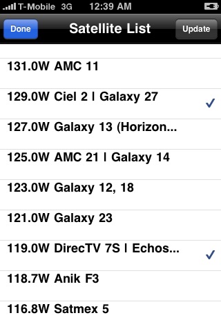
+ Select the satellites to be displayed from a list
+ Add or delete your own satellites to/from the list (PRO)
+ Displays satellite settings (azimuth, elevation, skew) and current magnetic as well as true heading for the screen center
+ Clarke Belt (satellite arc) is shown from east to west - all geostationary satellites are along this arc
+ When moving the iPhone laterally or vertically, the arc and the satellites move in real time with the live image
+ Ability to lock the compass, i.e. the arc wont move laterally anymore
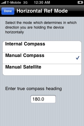
+For 3G users, ability to enter a lateral reference point, such as a manual compass reading or an existing satellite position
+ Ability to enter location

Why get the Pro version?
==============
+ Add your own satellites to the list, update them whenever you want - complete independence when satellite positions change or new ones appear - no need to wait for an official update. For business critical missions a must.
+Be on the safe side for future updates and new features. Pro version always take priority over the standard version.

Usage instructions
=========
3GS/4 users:
1. Switch it on and tap AR View button
2. In camera mode, look at the bottom label and rotate iPhone until it heads towards south (true heading = 180°). (People located on the southern hemisphere should point the iPhone north).
3. Lift the iPhone and watch the satellites appear
4. Move the device laterally and see the satellites moving too
5. Compass is sensitive to interferences but and works best when device is held flat. You can lock the compass in that position and lift the iPhone up but dont move it laterally then.

3G/iPod Touch users:
1. As above but set the lateral reference mode first. The app needs to know in which direction you are pointing the iPhone. So either enter a manual compass bearing compensated for magnetic declination or a satellite position if you have already a working satellite or used DishPointer Maps for a reference Point.
2. Lift the iPhone up and see the arc but dont move the iPhone laterally, as it wont get shifted.

NOTE: The app does not require Cell or internet, works on its own.

If you have any problems or feedback, please drop us a line at [email protected]. We are anxious to make this product work perfectly for every one of you.

DishPointer® is a registered trademark of DP Technologies Ltd

Pros and cons of DishPointer Augmented Reality app for iPhone and iPad

DishPointer Augmented Reality app good for

Very usefull for camping / caravaning. Thx for the iPhone 4 GPS / retina display update.
I have this vesion and the pro version. (Note the pictures which are showing currently are from the old version, this new version blows it away!) Just point your iPhone 3GS to the sky and instantly see where the satellites are in the sky. Know instantly if you have good line of sight to the satellites. This program is a must for any professional installer. This will save installers lots of time trying to figure out where to put the dish for the best line of sight.
Please ignore the reviews for the earlier version, particularly my own harsh review which, I hope, will be gone by now. This version 2 is actually a completely new application with nothing in common with the original. The developer apparently only submitted this new app in the slot for the earlier app as a way to give it to those of us who had bought the original. The earlier effort was worthy of the one or two stars it got. The new app is a revolution. This app will eliminate a major continuing frustration in the life of RVers who must locate satellites every time they move. For the first time, its easy to find a spot to park an RV where reception is not just promised, but actually possible. Hold the phone up and spin around until you see the satellites you need. If something is in the way, move to a different site. When nothing is in the way, youre done. Simple. My wife and I not only need to lock onto TV satellites, but Internet. We hold our breath every time we raise the Internet dish; the dishs reliability is well short of 100%. For the first time, there is no question about a problem being HugesNet or just where were parked. One of the first things I tried the app on was my roof installation at home: I found our trees are now within six feet of occluding satellite 110. That gives me more than a year to get around to either getting them topped or moving the dishes to a different part of the roof. (It took around 30 seconds of hopping around the roof to find a perfect new spot, one the original installer missed.) DishPointer AR works best on iPhone 3G S phones because of their built-in compass. It can be used on the older phones with a manual compass, but you have to set the direction using a manual compass or a known satellite bearing. If youve been looking for an excuse to upgrade to the 3G S, you no longer need an excuse: If you have an RV and must repeatedly struggle siting and aiming a satellite dish, this app is worth the price of the app plus the price of the phone. Where was this eight years ago when we first started our journey? Note to the suspicious: I dont normally write rave reviews. In fact, I originally gave the first, non-AR version of this same application a single star. I personally have never seen an app improve so much between releases, but thats because the developer went back to the drawing board and started over. The app needed it, and the results are stunning. Update: Helpful hints: 1) Wear a billed cap, like a baseball cap, when searching for a site during the heat of the day. Not only are the satellites to the south, so is the sun. (Yes, I know your mom told you not to look directly into the sun, but she never had to find satellite 110 through a hole in the trees.) 2) How to take a picture of your site survey, including the satellites in the picture: Press the power button (on top of the phone) and the home button (toward the bottom front of the phone) at the same time. Yes, its inconvenient, particularly since the power button is just above the camera lens, but Apple has yet to give developers a way to capture augmented-reality screens any other way. Blame Apple, not the developers.
Some reviewers clearly didnt read the full description before buying or using this app. The 3G (& earlier) does not have an integrated compass. If youre trying to use this app on that platform (as I was), you will need to manually enter your bearings (using a magnetic compass or some other point of reference), and you will only get an accurate reading tilting the phone along one axis (you can look up & down, but not left to right). To be sure, these are significant limitations, especially for a premium-priced app (a hard pill to swallow given that I, like most purchasers of the non-pro version, really only expect to use it one time). Nonetheless, it serves a unique function and saved me a tremendous amount of money, time, & heartache (no DirecTV for us), so I have to give props where theyre due. While I cant fault the developers for the compass issue, I do have one significant beef with the softwares design: it does not work in landscape mode. For those of us who cant pan left to right, some extra horizontal real estate would be much appreciated. (a suggestion to the developers for future editions: for the compass-impaired, itd be great if we could do this: 1) using the built-in maps, user selects a moderately distant visual point of reference - lets say a tall building which is visible on satellite photos. 2) app calculates bearings from current location to that point. 3) in the camera AR view, a vertical line is drawn representing that bearing; as long as the user manually lines up that axis with the landmark, they should have a reasonably accurate compass bearing. 4) User can drag the line left or right to fine-tune their bearings (as long as the user keeps that line on the landmark, the satellites will follow). 5) user can select another reference visible from the ground - say, a tree or mailbox post - which may be more convenient or allow a coarser compass adjustment (move your building to the right of the screen, select a post at the left, then drag that all the way to the right). Obviously, your bearings would become less accurate with each iteration, but this would still be a handy tool in a pinch.)
The best tool for sat instalers anywhere if you have the 3GS. I tell every installer I meet to get this timesaving tool that makes choosing your dish placement a breeze. The one function missing is ability to snap a pic in camera mode, that would be BIG!!! AL
Ive had this app for a year now and use it every time I do a survey. Its is tremendous help! Im also a satellite engineer and use it all the time! It is truly a magnificent thing to have. Absolutely love it!

Some bad moments

It can give you a rough idea but as soon as it is near the dish all of the satellites are out by miles. There are other apps that are cheaper and do the same thing
This is not a review. A question about "how to use this pointer"?
seems rather useless for a 3G phone. Not sure what i was expecting, but $9.99 for the 3G seems wrong. Perhaps a $.99 for 3G usage and $9.99 for 3GS.
Not the best accuracy that I expected. Voice interaction would be very helpful as you maybe 100 feet in the air !
Very untrustworthy. Ive been doing satellite for over 4 years now.. When i am looking for satellite 101 this app has it in the complete opposite sky majority of the time. Very unreliable. If I have it connected to wifi then it will lock in the sky very accurately. Something must be fixed for us field techs to maximize our assets
App works for the most part, but has distressing tendency to give a somewhat different location in the sky, for the same satellite, every time I use it. I guess its okay to get a rough idea of where a satellite is, but its no good for anything approaching precision aiming.